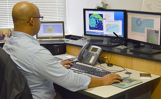
DEDICATED FORECASTERS AT THE BERMUDA WEATHER SERVICE HELP US STAY INFORMED
by Tim Smith
As you bunker down in your bed the next time Bermuda gets hit by a hurricane, spare a thought for the team at the Bermuda Weather Service.
Meteorologists work exhausting hours keeping us up to date with the latest storm news – taking turns to sleep in their training room – for as long as strong winds continue to batter the island.
“It’s our home for however long a storm may want to stick around for in Bermuda,” meteorologist Gary Hall said of the weather station in St David’s.
No stone is left unturned to ensure the weather team provides a round-the-clock service.
“We have inflatable mattresses and cots which we use if we need to sleep, because we are not leaving after our shift,” said Mr Hall in a video about the BWS operation.
“We will spend 12 hours in here, go back out and work another 12 hours for however long we have to work. We have showers down the hallway.
“We do have generators so that if the power goes out, which often it does, we are self-sufficient.
“We have a satellite phone – we are still going to be connected to the world. We still have power, so we are still able to be up and running to continue to provide you the best service possible.”
The BWS has performed a crucial role since it was set up to replace the skeleton meteorological service previously provided by the US Navy from the airport in 1995.
While Bermuda is under threat from a major storm, the BWS team produces tropical update bulletins – containing information such as wind speeds, storm location, direction and movement – every three hours.
Delivered to the public via the BWS website, automated telephone recordings, radio interviews and Facebook, as well as through press releases to all the island’s media, these bulletins are more accessible than ever before.
Thanks to advances in technology, the amount of information and its accuracy is also better than ever.
“At BWS, we use a scientific and technological approach to consistently observing and forecasting the weather,” Mark Guishard told The Royal Gazette.
“Our operations use tools such as numerical computer models, remote sensing technology such as Doppler radar and satellite imagery, but we are more reliant on rigorous professional training to identify phenomena and detect patterns.”
Introduced about 17 years ago, the Doppler system contains technology allowing meteorologists to keep an eye on weather systems hundreds of miles away, picking up key details about hurricane wind fields.
It was upgraded for $2 million two years ago to provide more accurate forecasts and deal with problems associated with the island’s isolated location and climate change.
The technology scans in two planes – horizontal and vertical – to give the radar a better definition of storms as they approach Bermuda.
It’s all a far cry from that fateful day in 1987 when Bermuda’s residents went to bed thinking Hurricane Emily was little to worry about, but woke up with one of the island’s most vicious storms almost on top of them.
Emily – the first direct hit by a hurricane in 24 years – is well remembered as the storm that turned out to be much worse than expected.
It moved at three times the speed of an average hurricane as it suddenly intensified, leaving hardly any time to prepare after the impact of the storm was first felt at 7.30am.
Hundreds of roofs were lost, motor vehicles were crushed and boats were sunk, while the Atlantic repeatedly smashed into the dock wall at Hamilton’s cruise port.
“The models have helped us a great deal in recent decades,” Dr Guishard said.
“Looking at the model errors in something like hurricane tracks, they have decreased a great deal, meaning forecasts are more accurate now than when Hurricane Emily impacted Bermuda. These days, that scenario is much less likely to catch us out.”
BWS’s staff includes five forecasters and five observers who have undergone training and certification with Britain’s Met Office as well as in-house training at BWS. Further specialist training is received at the National Hurricane Centre in Miami.
The team operates from a control room with multiple terminals showing minute-by-minute changes in weather via the Met Office and the National Weather Service in the United States.
But despite boasting state-of-the-art technology and a well trained and dedicated team, nobody at the BWS takes anything for granted.
“Even having all these tools in the toolbox doesn’t make our forecasts infallible,” Dr Guishard said.
“Remember, we are predicting the future state of a three-dimensional fluid, the atmosphere, in real-time, using an incomplete representation as a starting point.”
Some storms have proved easy to predict, such as Hurricane Paulette in 2019, which perfectly mirrored the National Hurricane Centre’s forecast.
But Dr Guishard said: “Some storms don’t behave themselves.”
These include Fay, which formed on the doorstep in 2014, and Teddy, which stalled and meandered south of the island in 2020.
Another unpredictable storm was Karen, which was predicted to pass west of the island with gale-strength winds in 2001, only to change character overnight and begin producing hurricane force winds as it moved past Bermuda.
Dr Guishard said: “In these instances, the science of meteorology is still incomplete, and the observational network insufficient to properly predict the scenario.
“The high impact and low predictability nature of hurricanes is what sets them apart from most non-tropical weather systems.
“As many who live in Bermuda will know, a small change in the track forecast for a hurricane makes a big difference in the predicted impacts we face here. Subtle changes of just 50km or so can mean the difference between hurricane force and much less intense wind speeds.”

