EMILY DAMAGES 2,500 HOMES AFTER BARRELLING INTO BERMUDA
By TIM SMITH
Heavy showers and winds of less than 50mph were predicted as the diminishing storm Emily approached Bermuda in September 1987.
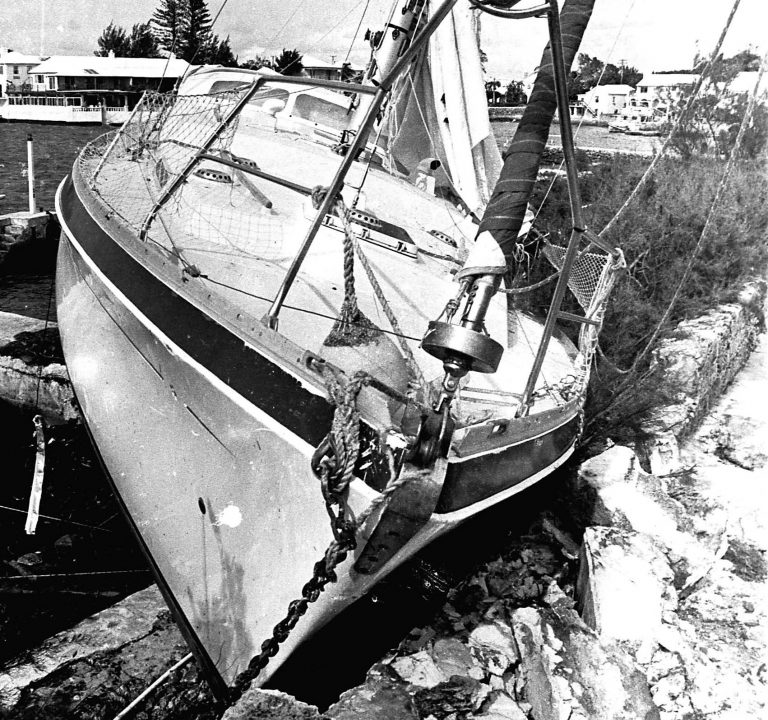
A few hours after that weather forecast was delivered, hundreds of roofs had blown off homes and public buildings, hotels suffered extensive damage, many cars and boats were crushed, a cruise ship smashed repeatedly into a dock wall, numerous telephone poles and trees were downed and dozens of people were injured by flying debris.
Emily was the hurricane that caught Bermuda by surprise.
The storm had already wreaked havoc in the Caribbean, including in the Dominican Republic, where two people were killed in mudslides and another by stepping on a fallen power line.
But as it made a path towards Bermuda, Emily was downgraded to a tropical storm that was expected to pass south of the island on September 25. Maximum winds were expected to reach between 34mph and 46mph.
The night before the storm, Commander Frank Bub of the United States Naval Air Station said heavy rain and thunderstorms could be expected late afternoon, adding: “It should clear up nicely.”
By 3.45am, with Emily still some 215 miles away from Bermuda, its winds suddenly picked up to 85mph and forecasters detected air pressure dropping rapidly.
With most of the island asleep, a hurricane advisory was issued at 4am.
Fate then conspired against Bermuda as Emily developed into a Category 2 hurricane and barrelled towards the island at 45mph – three times as fast as a normal hurricane – and struck as early as 7.30am.
Winds of up to 116mph made it the worst storm to hit Bermuda in four decades, and National Hurricane Centre forecaster Bob Case later conceded: “It was the perfect example of everything that could possibly go wrong meteorologically.”
Fierce winds for a two-hour period – including tornadoes and a ferocious waterspout – caused an estimated $50 million of damage, the equivalent of $120 million today.
Khyber Pass resident Winston “Super” Lottimore told The Royal Gazette how he watched a waterspout rip the roof off the dining room at the Mermaid Beach Club in Warwick.
“I saw this big orange, grey and white ball come out of the water. It looked like it was a quarter of a mile in height and it was as wide as a football field,” Mr Lottimore said.
“It came up out of the water and got bigger and bigger as it approached land. I could see it twist into a funnel shape and then I ran away to get away from it.”
The waterspout tore through Mermaid Beach then cut across Warwick and demolished everything in its path.
The cruise ship Atlantic, carrying 825 passengers, broke its moorings at the Hamilton docks and smashed into the dock wall repeatedly.
“It was very scary,” said eyewitness Ed Marshall. “The stern just kept smashing into the dock and she was listing right over.”
Further damage was recorded at Marriott Castle Harbour Hotel, whose building was ravaged, and the Southampton Princess Hotel, where windows were shattered in 80 rooms.
Damage was recorded to 2,500 homes, including more than 200 which lost roofs; parts of the roofs were torn off at LF Wade International Airport, City Hall in Hamilton and St Brendan’s hospital in Devonshire.
Five National Trust properties, including the historic Verdmont and the Winterhaven farmhouse, were damaged.
Although nobody was killed, the emergency room at King Edward VII Memorial Hospital faced a stream of injured people throughout the day.
One woman who took her mother for treatment said: “It was like a war zone. There were people literally standing around with bloody wounds on their heads and faces.”
Hundreds of people were without power for several weeks, leading to a revamp of the Belco system costing millions of dollars.
Part-time soldiers from the Bermuda Regiment led a major clean-up operation after Premier Sir John Swan opted against bringing in professionals from overseas.
It was such a success, hurricane recovery has now become of the Regiment’s most important regular roles.
But even as Bermuda began to get back on its feet, residents were unhappy at the national failure to prepare for the storm.
Meteorologists admitted they had been caught flat-footed by a freak push of air from the East Coast of the United States that sent Emily hurtling towards Bermuda.
Forecaster Mr Case conceded they had underestimated Emily’s unpredictability because they had so accurately predicted her path and force during the previous week.
“We had such a great batting average with this storm that we may have become a little too confident about its predictability,” he told the Gazette.
This meant that instead of issuing an overcautious prediction, the Hurricane Centre forecast it “exactly as we felt it was going to happen”.
Mr Case said: “It shows you how quickly these things can change in a short period of time. Emily combined everything it had to deliver the worst possible damage that it could as a Category 2 hurricane.
“Bermuda was very unlucky. A lot of the time we get accused of over-warning or crying wolf.
“We do this because we don’t have the capability of making a perfect forecast.
“But there are things we cannot forecast. This is a perfect example of our limitations.”
These days, rigorously trained staff at the Bermuda Weather Service use state-of-the-art technology to gather information on hurricane wind fields and any other approaching hazards from many miles away.
And while hurricanes remain unpredictable, the haunting memory of Emily should mean Bermuda will never be caught off its guard through complacency again.

